


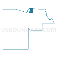
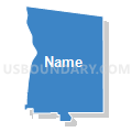
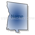
NEW RIVER Voting District, Maricopa County, Arizona
About
Outline

Summary
| Unique Area Identifier | 524877 |
| Name | NEW RIVER Voting District |
| County | Maricopa County |
| State | Arizona |
| Area (square miles) | 97.61 |
| Land Area (square miles) | 97.59 |
| Water Area (square miles) | 0.02 |
| % of Land Area | 99.98 |
| % of Water Area | 0.02 |
| Latitude of the Internal Point | 33.95263060 |
| Longtitude of the Internal Point | -112.07106210 |
Maps


Graphs
Select a template below for downloading or customizing gragh for NEW RIVER Voting District, Maricopa County, Arizona


Neighbors
Neighoring Voting District (by Name) Neighboring Voting District on the Map
- BISCUIT FLAT Voting District, Maricopa County, AZ
- Canyon Voting District, Yavapai County, AZ
- CAVE CREEK Voting District, Maricopa County, AZ
- DESERT HILLS Voting District, Maricopa County, AZ
- GAVILAN PEAK Voting District, Maricopa County, AZ
- INSPIRATION Voting District, Maricopa County, AZ
- LAUREL GREENS Voting District, Maricopa County, AZ
- PIONEER VILLAGE Voting District, Maricopa County, AZ
- WOLF RUN Voting District, Maricopa County, AZ
Top 10 Neighboring County Subdivision (by Population) Neighboring County Subdivision on the Map
- Deer Valley CCD, Maricopa County, AZ (258,464)
- Tonto National Forest CCD, Maricopa County, AZ (9,713)
- Congress CCD, Yavapai County, AZ (9,623)
- Cordes Lakes-Mayer CCD, Yavapai County, AZ (6,550)
Top 10 Neighboring Place (by Population) Neighboring Place on the Map
- Phoenix city, AZ (1,445,632)
- Anthem CDP, AZ (21,700)
- New River CDP, AZ (14,952)
- Cave Creek town, AZ (5,015)
- Black Canyon City CDP, AZ (2,837)
Top 10 Neighboring Elementary School District (by Population) Neighboring Elementary School District on the Map
Top 10 Neighboring Unified School District (by Population) Neighboring Unified School District on the Map
- Deer Valley Unified District, AZ (239,044)
- School District Not Defined, AZ (69,809)
- Cave Creek Unified District, AZ (56,235)
- Mayer Unified District, AZ (5,679)
Top 10 Neighboring State Legislative District Lower Chamber (by Population) Neighboring State Legislative District Lower Chamber on the Map
- State House District 4, AZ (294,239)
- State House District 6, AZ (219,170)
- State House District 7, AZ (190,272)
Top 10 Neighboring State Legislative District Upper Chamber (by Population) Neighboring State Legislative District Upper Chamber on the Map
- State Senate District 4, AZ (294,239)
- State Senate District 6, AZ (219,170)
- State Senate District 7, AZ (190,272)
Top 10 Neighboring 111th Congressional District (by Population) Neighboring 111th Congressional District on the Map
Top 10 Neighboring Census Tract (by Population) Neighboring Census Tract on the Map
- Census Tract 6103, Maricopa County, AZ (8,959)
- Census Tract 6102, Maricopa County, AZ (7,612)
- Census Tract 6107, Maricopa County, AZ (7,193)
- Census Tract 6100, Maricopa County, AZ (7,044)
- Census Tract 15, Yavapai County, AZ (6,550)
- Census Tract 6105, Maricopa County, AZ (6,496)
- Census Tract 101.02, Maricopa County, AZ (4,640)
- Census Tract 14.01, Yavapai County, AZ (2,500)
- Census Tract 6101, Maricopa County, AZ (1,322)